 By
Sam Lepore
By
Sam Lepore
"The journey of 1,000 miles begins with the first mile."
So signs Will Lee, a Long
Distance Rider from San Francisco. Although we live in the same city, Will
and I have never met closer than 300 miles from home - last time was north
of Seattle. We travel. Will is the only person I know crazy enough (and
capable enough) to actually believe his Harley is a serious long distance
bike, but he has proven it. Being a true LDRider, he is also crazy about
good/big food. The last time he was "passing through" Idaho he wrote about
the world's best chiliburger he found in the tiny town of Horseshoe Bend.
Guess where I found myself.
The Riverside Restaurant
does indeed have the best open-face, half pound, completely covering the
8-inch circular plate, 3-inch tall pile of chili-cheese-salsa-with-chopped-olives-and-scallions-on-burger
that I have ever had for breakfast. Urp. My timing wasn't so good, but
I wasn't going to pass this up no matter what! Will gets the burgermeister
gastronome award. (Note to chili purists: this is not Texas chili ... it
has beans.)
Yesterday I mentioned the
rock cairn/piles in the fences in Oregon. As soon as I crossed the Idaho
border I noticed there were no cairns in the fences. Beyond just custom,
isn't it curious that what is so ubiquitous as to appear necessary a few
miles away simply does not exist over here ... but then Oregon requires
motorcyclists to wear helmets and Idaho doesn't, so maybe piling rocks
is written into the law. Just one of the mysteries I shall leave unsolved
...
Who would have though the
width of a river could effect such a difference. On the west side of the
Snake, every Oregon field I saw had "functional" vegetables growing - spinach,
squash, tomatoes, even potatoes. Immediately east of the border, there
was nothing but spices - green onions, dill, some feathery plant whose
smell I recognize as a spice but can't identify. How complimentary, but
how strange.
North of Horseshoe Bend,
the wonderfully sinuous ID55 follows the Payette River. The curves are
wonderful for motorcycles, but it seems a lot of them have their vivid
reminders of what can happen when a vehicle doesn't make the curve. We
have all seen the crosses at the side of the road, usually small and white,
occasionally with plastic flowers or a wreath. Some states allow if not
encourage their placement as a cautionary reminder to others of the dangers
of the road; some states are now removing them as 'unauthorized' distractions
and unsafe places to visit. No matter what you think, one I saw today was
a heart grabber.
As I flew past (55 in a
55) concentrating on looking through the curve and scanning the road camber
to set up for the next apex, the corner of my eye caught large purple writing
on the K-rail lining the road edge near the white cross. (K-rail is what
DOT calls those concrete barriers used to divert lanes in construction
areas.) I turned around and went back to see. The whole family had written
an individual message to the man who died at this spot. The large purple
was from Tiffany, who I surmise is a teenager by the handwriting style.
There was another, from son Ryan "Hope the fishing is good up there, Dad".
A lovely message from his wife, which I shall leave private. Another long
message from an indecipherable name, looked male. And at the bottom, about
6 inches above the dirt, in the uneven scrawl of someone who just recently
learned to print, done in what looked like crayon "Happy Fathers Day. Me"
As Sergeant Esterhaus used
to say, let's be careful out there.
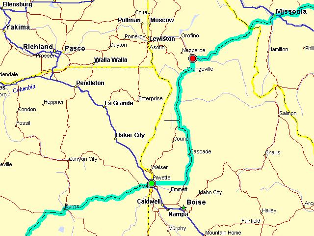
"Any road named River Road"
says a friend of mine. So right! The Payette River and the Little Salmon
and the Salmon make for a great day in the saddle. Central Idaho is incredibly
rugged and the roads have almost no choice but to follow the rivers ...
which, by the way all seem to be higher and faster than I expected this
late during the runoff. The Payette in particular was only a foot or two
from flood and very rapid. Roads to consider are ID55, US95, and a sleeper
of a peg scraper from Grangeville to Kooskia that I've never found before
- ID13.
Today is the first day of
summer. Idaho doesn't know that. Why, pray tell, was I wearing my electric
jacket and heavy gloves only one day after watching ice cream cones melt
faster than kids could lick them? Then, suddenly, the answer was presented
to me on a large roadside sign: YOU ARE HALF WAY TO THE NORTH POLE.
The 45th parallel crosses Idaho (and perhaps nowhere else :) here and the
good folk of the town of New Meadow have seen fit to startle passers by.
Considering the cool temperatures and grey skies, I'll just call this the
Lower 48 Version of the Arctic Circle.
I played dance with the
clouds most of the day, and sometimes they stepped on my feet. But each
of three times I closely approached a big black wetbelly that meant I'd
have to stop and suit up my luck turned with the road and I passed just
ahead or behind of the squall. Despite the frequent sprinkles, I count
today as a no-rain but not dry day. But three times is enough. Rather than
start the Lolo Pass late in the day and chase storms to the summit, it's
an early stop.
FuelPlus 253 miles, 5:20 hours, 48 mph average
Ontario US30 ID72 ID52 ID55 US95 ID13 Kooskia
Plans (subject to change) Bozeman, then Belle Fourche
Sam Lepore, San Francisco
________________
Wanderlust Rider